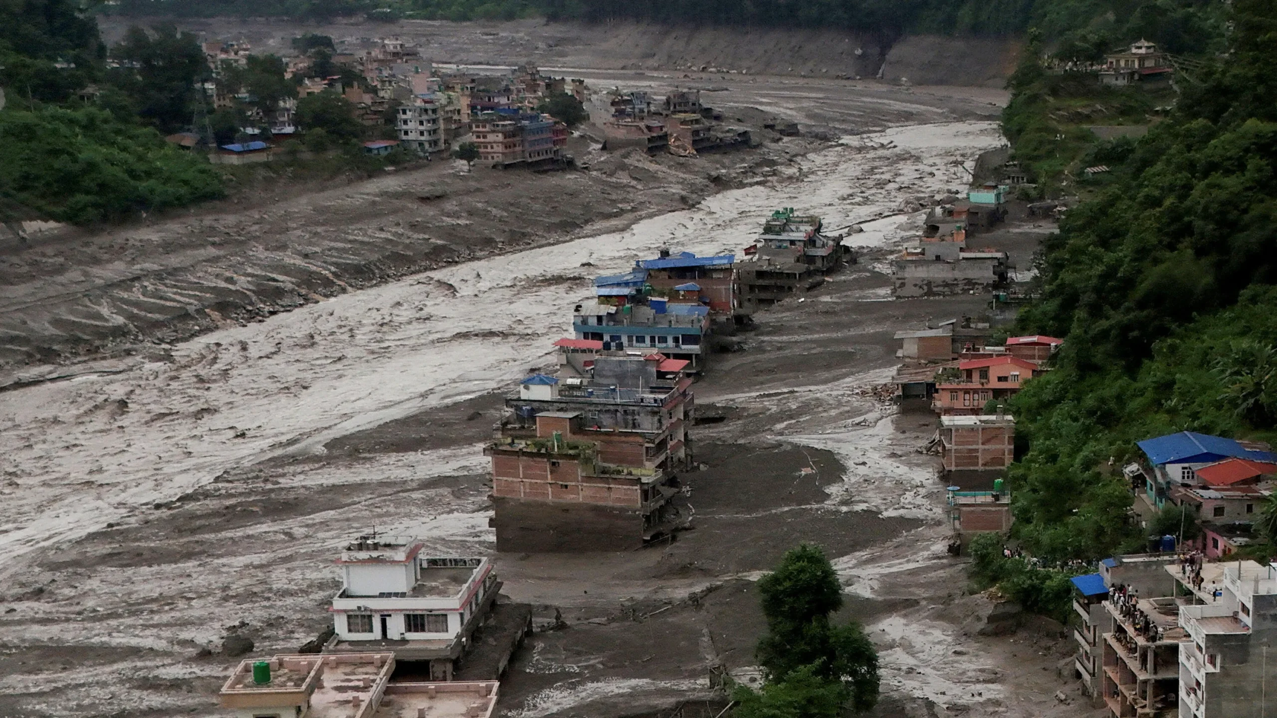
It took less than a minute. Surveillance cameras on the Chinese side of the Rasuwagadhi crossing caught the moment a grey-brown wall of mud, rock and water rose above a multi-storey building and swallowed it whole while people sprinted for higher ground. By Thursday evening, Nepal Police had confirmed 359 dead. Chinese authorities reported three more across the border. Somewhere between 1,300 and 1,500 people are still unaccounted for, and nearly every official who has spoken publicly has said the same thing: that number is going to get worse before it gets better.
This is the deadliest single-day disaster Nepal has faced since the 2015 earthquake, and unlike a monsoon flood, almost nobody saw it coming.
What Happened on Wednesday Morning
The flood began around 8:40 a.m. local time on August 26. A mass of ice and rock broke away from a glacier roughly 20 kilometres upstream of the Miteri Bridge and crashed into the Lhende Khola, a tributary of the Bhote Koshi that runs along the border. The debris dammed the river. For a while, water piled up behind it. Then the dam failed, and everything that had been held back came down the valley at once.
Timure, Syabrubesi and the Rasuwagadhi border post took the direct hit. The surge then poured into the Trishuli and kept going — through Nuwakot, Dhading, Gorkha, Chitwan and into the Narayani. Bodies have been recovered more than a hundred kilometres downstream, in Chitwan and Nawalparasi, which tells you something about the force involved that no photograph really can.
It Was Never an Earthquake
Early reports out of Kathmandu suggested a magnitude 4.4 quake had shaken the glacier loose. That reading has since been corrected. The tremor instruments picked up wasn’t tectonic at all — it was the seismic signature of the collapse itself, millions of tonnes of ice and rock letting go and hitting the valley floor. Satellite analysis of the area supports the same sequence: landslide first, debris dam second, catastrophic release third.
Meteorologists have also ruled out heavy local rain in Rasuwa as a trigger. There was rainfall on the Tibetan side, but this was not a monsoon event. It was a mountain failing.
The Missing Are Mostly Foreigners
The geography here matters. This corridor is the main overland route between Kathmandu and Lhasa, and August sits in the middle of pilgrimage season for Mount Kailash and Lake Mansarovar — sites sacred to Hindus, Buddhists, Jains and followers of the Bon tradition. The valley was full of tour buses, trekkers, customs staff, hydropower workers and truck drivers when the water arrived.
Nepal’s disaster authority puts the missing on its side of the border at roughly 826 to 910 people, of whom around 590 were tourists. Chinese state media reports 558 missing in Gyirong county, including 260 foreign nationals. It’s not yet clear whether the two governments are double-counting some of the same people, so treat the combined totals with caution.
Among the foreign nationals listed as missing by Nepal’s tourism board:
- India — 177 (Indian officials have cited higher figures)
- United States — 63
- Australia — 34 to 35
- United Kingdom — 33
- Canada — 25
- Plus travellers from more than two dozen other countries
Nepal’s own losses inside the state apparatus are severe: 44 army personnel, 28 police officers and 13 members of the Armed Police Force are unaccounted for, along with roughly 160 workers from hydropower sites and customs offices.
Rescue Work Where the Roads No Longer Exist
More than 5,000 army and police personnel are on the ground, and 125 people were pulled out alive on Thursday alone, including 20 foreigners. But the response is running into a hard physical limit. A 42-kilometre stretch of road from Betrawati to the Rasuwagadhi crossing has been destroyed or buried. Concrete bridges are gone. One helicopter sent to Timure had to turn back because the helipad had been washed away.
Everything now moves by air. India has flown in tents, food and medicine. The US State Department has committed $500,000 and a disaster response adviser. UN agencies and the World Food Programme are mobilising, and aid workers estimate more than 30,000 households will be affected. Prime Minister Balendra Shah travelled by road to Bidur in Nuwakot on Thursday to see the damage himself, after releasing Rs 1 billion to the national disaster relief fund.
There’s also a live secondary threat. Chinese authorities have warned that a lake upstream in Gyirong is still dammed by debris, with millions of cubic metres of water flowing into it. If that lets go, rescuers working downstream are standing in the path.
Nepal’s Power Grid Took a Serious Hit
Beyond the human toll, this flood punched a hole in Nepal’s electricity system. The corridor it tore through is one of the country’s most concentrated hydropower zones.
| Impact | Figure |
|---|---|
| Operating projects damaged | 12, around 431 MW (including a 25 MW solar plant) |
| Under-construction projects damaged | Up to 15, roughly 470 MW of future capacity |
| Worst-hit single plant | Rasuwagadhi, 111 MW |
| Districts with disrupted supply | Rasuwa (total blackout), Nuwakot, Dhading, Gorkha (partial) |
Chilime, Upper Trishuli 3A, Trishuli, Devighat and a 220 kV substation are all on the damage list. Insurers have already signalled that claims will take weeks to even assess, because most of the sites can’t be reached by road. For a country that has spent a decade building its way out of chronic load-shedding, losing several hundred megawatts in a morning is a setback measured in years, not months.
The Same River, Twice in Fourteen Months
Here’s the part that should be uncomfortable for everyone involved. The Lhende Khola did this before. On July 8, 2025, a supraglacial lake in Tibet drained into the same watercourse, killed at least nine people, swept away the Friendship Bridge and knocked out over 200 MW of generation. That event was studied. Scientists wrote it up. And then, almost exactly one year later, the same tributary produced a disaster more than thirty times deadlier.
Researchers who monitor the Hindu Kush Himalaya have been blunt: the range is warming faster than the global average, roughly 60,000 glaciers in the region are destabilising, and cascading hazards — avalanche feeding landslide feeding debris dam feeding outburst flood — are arriving at a pace nobody has good data for. One hydrologist who has spent his career on Himalayan ice called this the worst such event he can recall.
The gap isn’t scientific understanding. It’s monitoring and warning. There is no meaningful early-warning system on this stretch of the border, no shared real-time instrumentation between Nepal and China on a river that starts in one country and destroys towns in the other. Wednesday’s surge took roughly an hour to reach populated areas downstream. An hour is enough time to save a lot of people, if anyone is watching and anyone can be told.
What This Means
The immediate story is a search operation racing a monsoon calendar in terrain that has erased its own access routes. Expect the death toll to keep climbing for days as the mud is cleared and downstream districts recover bodies.
The longer story is harder to look at. Nepal did not fail at disaster response here — its army and police were mobilised within hours, and rescue crews have been credible under impossible conditions. What failed was everything upstream of the disaster: the absence of glacial-hazard monitoring on a known-dangerous tributary, the lack of cross-border data sharing on a river that ignores the border entirely, and a development model that has parked hydropower plants, customs yards, hotels and highways directly in the runout path of an unstable mountain.
Rebuilding the road and the bridges will take a season. Rebuilding the power projects will take longer. But if the reconstruction puts the same infrastructure back in the same places without sensors on the ice above them, the region will be reading a version of this article again — and the interval between the last one and this one was fourteen months.